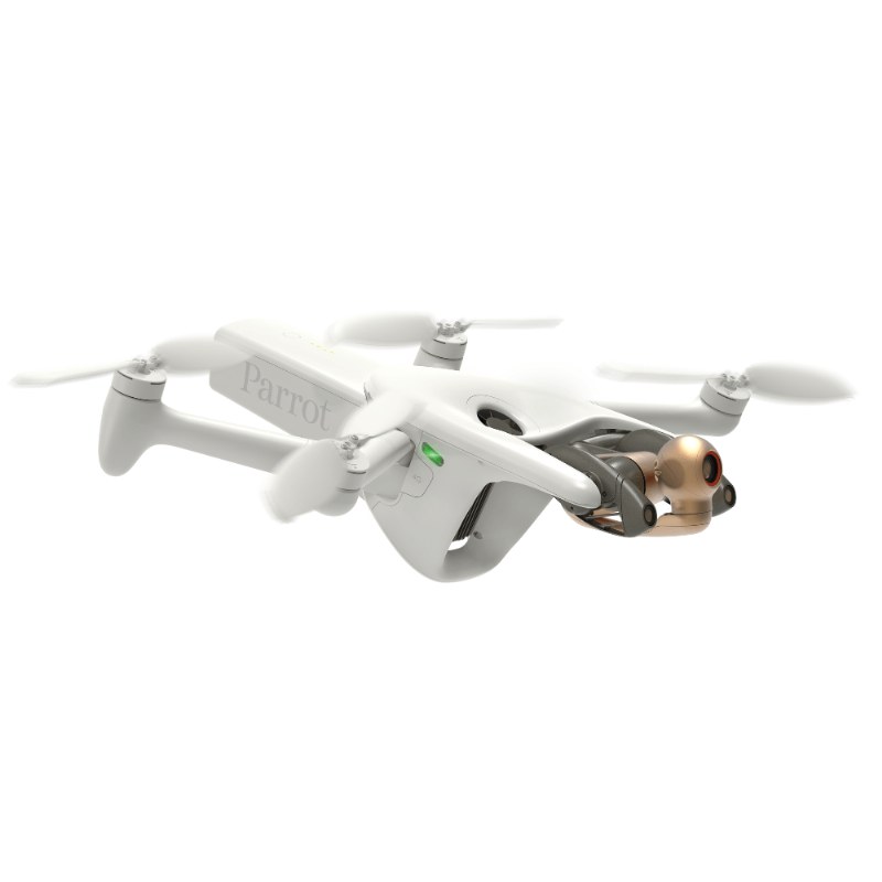
The Parrot ANAFI Ai is the first commercial 4G robotic drone made for professionals to provide large-scale mapping and detailed aerial data. It features a 48 MP camera, autonomous photogrammetry, and can transfer data in-flight. Thanks to the 4G connectivity, it offers an unlimited range and access to global networks, making it ideal for mapping, inspections, and remote monitoring.
One of the key features of Anafi Ai is the
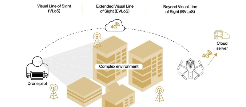
4G module, which covers over 98% of locations worldwide. This keeps the connection stable, even in remote or obstructed areas where Wi-Fi is not available. The drone connects to the 4G Skycontroller remote within 30 seconds when out of Wi-Fi range and in less than 15 seconds when in range, making the drone very quick to deploy. This feature also allows the Anafi Ai drone to perform
BVLOS flights - beyond visual line of sight - so it can cover large distances for tasks such as surveying, inspections, or remote site monitoring. Thanks to the 4G, the drone can also transfer files to the cloud while in flight.
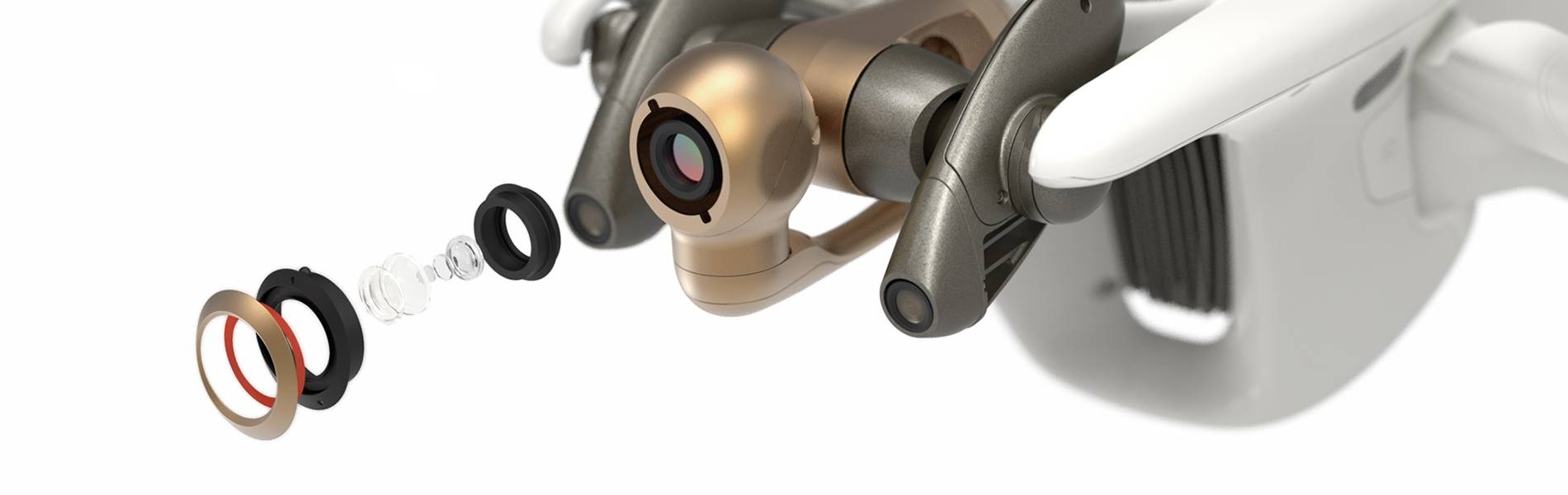
The Anafi Ai has a 48 MP camera that captures detailed, high-resolution photos and 4K videos with HDR10, bringing out natural, vivid colors. There are several different camera modes available like panorama, burst, bracketing, timelapse and GPS lapse. The 6x zoom allows it to capture 1 cm detail at 75 meters away, while the featured burst mode takes 10 images per second, making it an ideal drone for capturing fast-moving scenes. To provide smooth footage, the camera also has a 6-axis stabilization (mechanical + electronic) and can tilt from -90° to +90°, making it flexible for different angles of viewing. Multiple different flight modes are available also to choose from, such as Flight Plan, Cameraman, Hand Take-off, and Smart RTH, for better flexibility in different tasks.
For mapping and surveying, Anafi Ai's
autonomous photogrammetry function is powered by the built-in artificial intelligence, which lets it plan, complete mapping, and survey flights automatically, making any needed work done faster and more efficient. The drone is fully compatible with third-party software such as the
PIX4D suite and supports 48 MP image capture at 1 frame per second, making it twice as fast as some competitors. It also features an AI-powered obstacle detection, which is managed by rotating twin sensors that detect objects up to 30 meters away. While flying, the drone also constantly updates the navigation to avoid obstacles in real time.
Parrot drones are built to handle different environments, and the Anafi Ai is
IPX3-rated, meaning it can fly in rain and handle winds up to 50.4 km/h. It provides 32 minutes of flight time, can be ready to fly in 60 seconds, and weighs less than 1 kg.
Security is a key feature for Parrot. The Anafi Ai uses
strong 4G authentication and digitally signed images, ensuring all data transfers are secure and protected from any unauthorized access. It also uses a Secure Element to encrypt the 4G connection between the drone and the Skycontroller remote.
Additionally, Parrot provides
Software Development Kit (SDK), which allows you to further customize and enhance the drone features by integrating with third-party applications and hardware, with a choice from over 60 Parrot global partners such as PIX4D, DroneSense, and AirData.
Each model comes with the Skycontroller 4 remote, cable accessories, a fast charger, an extra set of propeller blades, and gimbal protection, all packed in a hard case for safe transport.
Anafi Ai Main Features:
- 4G connectivity for operations across 98% of global frequencies
- Autonomous photogrammetry supports large-scale mapping with PIX4D compatibility
- In-flight cloud transfer for real-time data uploads
- Beyond Visual Line of Sight (BVLOS) operations
- 48 MP camera with 6x zoom captures 1 cm detail at 75 meters
- HDR10 Video captures high-quality videos with realistic colors
- AI obstacle avoidance detects objects up to 30 meters
- 32-minute flight time and ready to fly in 60 seconds
- IPX3-rated for rain resistance and wind speeds up to 50.4 km/h
- Digitally signed images
- Encrypted communications
- Software Development Kit for tailored solutions
Anafi Ai Full Technical Specifications:
ANAFI Ai drone
Size folded: 304 x 130 x 118 mm
Size unfolded: 320 x 440 x 118 mm
Weight: 898 g / 1.98 lb
Ready to fly in 60 seconds
Maximum flight time: 32 min
Maximum horizontal speed: 16 m/s – 34 mph
Maximum vertical speed: 4 m/s – 9 mph
Maximum wind resistance: 14 m/s – 31.3 mph during flight & 12 m/s – 26.8 mph during take-off and landing
Maximum propeller speed: 10,000 rpm
Service Ceiling: 5,000 m (above sea level)
Operating temperatures: -10°C to 40°C
IP53 certified: dust and rain resistant
Noise emission: 81 dB at 1 m
MicroSD and SIM card slots
Imaging system
Sensor: 1/2’’ 48MP CMOS
Dynamic range: 14 EV in HDR mode
Optical LD-ASPH (low dispersion aspheric lens):
Aperture: f/2.0
35 mm focal equivalent: 24 mm
Depth of field: 4.5 m to ∞
ISO range: 50 to 6400
Electronic shutter speed: 1/15 s to 1/10000 s
Zoom: 6x – lossless: up to 4x (1080p) & 2x (4K UHD)
6-axis stabilization:
Mechanical: 3-axis (pitch, roll and yaw)
Electronic (EIS): 3-axis (pitch, roll and yaw)
Controllable gimbal tilt range: -90° to +90°
Video specifications
Resolution:
4K UHD: 3840x2160 - 24/25/30 fps
1080p: 1920x1080 - 24/25/30/48/50/60 fps
HDR 10: 4K UHD/1080p - 24/25/30 fps
HDR 8: for all resolutions
Horizontal field of view (HFOV): 68°
Maximum video bandwidth: 200 Mbps
P-log for professional video editing
Photo specifications
Formats: JPEG, DNG (Digital NeGative RAW)
Resolution: 48 MP (8000x6000), 12 MP (4000x3000)
Horizontal field of view (HFOV): 73° (Wide), 69° (Wide with EIS), 65° (Rectilinear with EIS)
Modes: Single, Bracketing, Burst (10 fps), Panorama (4 formats), Time-lapse, GPS-lapse
Connectivity
Seamless Wi-Fi - 4G switch
Streaming with low latency (300ms average)
Worldwide LTE compatibility
Autonomous flight
Photogrammetry: single grid, double grid, orbit
Flight Plan: multiple Waypoints and Points Of Interest
Cameraman: automatic framing with visual tracking
Smart RTH: customizable return altitude
Vehicle: flight adapted to controller location reference
Navigation system
Satellite navigation: GPS, Glonass and Galileo
Vertical camera & Time of Flight
Barometer and magnetometer
2 x 6-axis inertial units (flight and camera):
2 x 3-axis accelerometers
2 x 3-axis gyroscopes
Stereoscopic cameras mounted on a 330° rotating gimbal (-120° to +210°) for obstacle avoidance
AI trajectory optimization system
Indoor flight
Cybersecurity
Zero data shared without user consent
FIPS140-2 compliant and CC EAL5+ certified Secure Elements
Strong authentication for 4G
Digitally signed pictures
Transparency and Bug bounty continuous security check
Parrot Skycontroller 4 remote
Size without terminal: 238 x 147 x 55 mm
Maximum size: 310 x 147 x 55 mm
Weight: 606 g / 1.34 lb
Transmission system: Wi-Fi 802.11a/b/g/n & 4G
Frequency of use: 2.4 GHz – 5 GHz
Direct video stream resolution: 1080 p
Battery capacity: 3.350 mAh 7.2 V
Compatible with all smartphones and up to 8"
Charges smartphones and tablets
Ports: 2xUSB-C (charging and connecting), micro-HDMI
Dust resistant (IP5X)
Drone smart battery
Type: High Density Lithium Polymer (262 Wh/kg)
Capacity: 6800 mAh 4.4 V
Charging port: USB-C
Weight: 366 g / 0.81 lb
Maximum charging power: 45 W
Parrot FreeFlight 7 application
Free App, no subscription fee
App available on the App Store
Compatible with iOS 12 and higher
3 free 3D models, courtesy of PIX4Dcloud
Parrot SDK
Air SDK: robotic framework
Ground SDK: iOS & Android App development kit
OpenFlight: open-source core of FreeFlight 7
Sphinx: 3D realistic environment simulator
Olympe: python controller programming interface
PDrAW: video viewer for pipeline implementation
Anafi Ai Feature Focus
Integrated 4G module for worldwide connectivity
Unlike traditional drones that rely on Wi-Fi or radio signals, the ANAFI Ai uses 4G as its primary communication link, ensuring stable long-range operation. Covering 98% of global frequencies, this enables the Anafi Ai to perform Beyond Visual Line of Sight (BVLOS) flights, allowing you to conduct inspections, mapping, and monitoring over extended distances without interference or signal loss. The drone also connects to the supplied Skycontroller 4 remote within 30 seconds when out of Wi-Fi range and in less than 15 seconds when within range, making deployment fast and seamless. Thanks to the 4G, the Anafi Ai has the ability to transfer files to the cloud while in flight. This is particularly useful for teams working on time-sensitive operations, such as surveying, inspections, and emergency response.
AI-powered Autonomous Photogrammetry and Obstacle avoidance
The Anafi Ai’s AI-powered autonomous photogrammetry enables accurate, large-scale mapping and detailed surveying for industries like construction, real estate, and environmental monitoring. It is fully compatible with the PIX4D suite, and the drone supports 48 MP image capture at 1 frame per second, simplifying data collection and improving productivity. To ensure safe navigation, the drone features advanced obstacle avoidance using rotating twin sensors that detect obstacles up to 30 meters away. Its stereo cameras, which are mounted on a rotating gimbal with 311° coverage, continuously monitor the surroundings and update an AI-driven occupancy grid in real time. This system optimizes navigation, especially during complex maneuvers in crowded or risky environments, such as urban areas, telecom towers, and wind turbines. These features make the Anafi Ai highly effective for flying in tight spaces or industrial sites.
High-Resolution 48 MP Camera with 6x Zoom for close-up details
The included 48 MP Quad Bayer sensor provides great detail, capturing 1 cm details at 75 meters away. The 6x zoom can also precisely collect data without needing to fly close to structures, making the drone useful for infrastructure inspections and mapping. The HDR10 video enhances image quality with realistic colors, while the 14 EV dynamic range provides clear visuals in both professional videography and surveying scenarios, and burst mode captures 10 frames per second, ideal for high-speed tasks. The Anafi Ai is stabilized by a 6-axis hybrid stabilization system (mechanical + electronic) to provide smooth and clear footage and reduce any motion blur. The camera has a tilt range of -90° to +90°, allowing flexible positioning for inspections, mapping, and cinematic shots.
Compact and Weather-Resistant Design
The Anafi Ai offers a 32-minute flight time on a single battery charge, and the drone can be ready to fly in under 60 seconds for quick deployment. It is IPX3-rated weather resistant meaning it can fly in rain and withstand winds up to 50.4 km/h, making it reliable in various conditions. The drone’s compact design adds to its versatility, allowing for easy transport and quick deployment, minimizing delays during field operations.
Strong Cybersecurity Measures
The ANAFI Ai is designed with strong cybersecurity measures to ensure data integrity and privacy during operations. It features strong 4G authentication, digitally signed images, and encrypted data transmission, making it a reliable option for sensitive applications. The drone also incorporates a FIPS140-2 compliant Secure Element, which encrypts the 4G connection and prevents any data sharing without user consent. These security features make it well-suited for government, enterprise-level, and other professional missions requiring secure drone operations.
SDK and Developer-Friendly Tools
Parrot offers extensive developer-friendly tools and customization through its Software Development Kit (SDK). Developers can run real-time, in-flight code and access advanced sensors, such as obstacle avoidance cameras and an occupancy grid, allowing the Anafi drones to be tailored for specialized applications.
Anafi AI Pack Contents:
1x ANAFI AI drone
1x hard case
1x Skycontroller 4 remote
1x smart battery
1x USB-PD (Power Delivery) fast charger
1x USB-C – Lightning cable
2x USB-C – USB-C cables
1x calibration chart
1x additional set of propeller blades
Parrot ANAFI Ai FAQs
What is the maximum flight time of the ANAFI Ai?
The ANAFI Ai offers up to 32 minutes of flight time on a single battery charge, making it suitable for extended missions.
Can the ANAFI Ai fly in adverse weather conditions?
Yes, the drone is IPX3-rated, meaning it can fly in light rain and withstand winds of up to 50.4 km/h, making it reliable in various weather conditions.
How does the AI-powered obstacle avoidance work?
The drone uses rotating twin sensors to detect obstacles up to 30 meters away. Its AI-driven occupancy grid updates in real time, ensuring safe navigation in complex environments like urban areas or industrial sites.
Is the ANAFI Ai suitable for professional mapping and surveying?
Yes, the drone’s autonomous photogrammetry function, compatibility with PIX4D, and 48 MP image capture at 1 frame per second make it ideal for large-scale mapping, surveying, and inspections.
What cybersecurity measures does the ANAFI Ai have?
The drone features strong 4G authentication, digitally signed images, encrypted communications, and a FIPS140-2 compliant Secure Element to ensure data integrity and prevent unauthorized access.
Can I customize the ANAFI Ai for specific applications?
Yes, Parrot provides a Software Development Kit (SDK) that allows developers to integrate third-party applications, access advanced sensors, and tailor the drone for specialized tasks.
What is included in the ANAFI Ai package?
The package includes the ANAFI Ai drone, Skycontroller 4 remote, smart battery, USB-PD fast charger, USB-C cables, a calibration chart, an extra set of propeller blades, and a hard case for safe transport.
What are the key camera specifications and capabilities?
The drone features a 48 MP Quad Bayer sensor with a 6x zoom that captures 1 cm details at 75 meters, supports HDR10 video in 4K and 1080p, offers multiple shooting modes (including burst, panorama, and time-lapse), and uses a 6-axis stabilization system for smooth footage.
Note
For more information about features, availability, pricing, ordering process, or similar, please don't hesitate to contact us at
[email protected], WhatsApp, Skype, or Telegram.
>>Download detailed specifications (PDF)<<
.png)
.png)
.png)
.png)
.png)
.png)

<br>Range of Detection: Up to 2 km (A1000), 5 km (A2000), 8 km (A8000)<br>Detection Frequency: 300 MHz ~ 6 GHz<br>")

 encryption<br>Deployed in under 55 seconds<br>Software Development Kit (SDK)<br>")